Easy, 24/7 access to kilometres of flat-top dyke trails offers amazing opportunities to view a large diversity of wildlife. Year round trail access allows visitors to access the by hiking, biking, snowshoeing and cross-country skiing. Self-guided walking trails, covered multi level viewing towers and boardwalk trails provide the ideal means to explore the Area.
Dogs are allowed on the trails at the CVWMA but they must be on leash. Also, please pick up after your pet. We are concerned with the amount of dog poop being seen on the trails and boardwalks and the number of dogs who are not on leashes. Please respect these rules for the safety of wildlife and for the comfort of other users of the CVWMA.
The CVWMA is home to nearly 400 different species of wildlife. In order to protect them and their habitat:
Check out the following maps for more details on the dyke trails and water access:
CVWMA Access Map (PDF)
CVWMA Trails Map (PDF)
Duck Lake Contour Map (PDF)
Corn Creek Marsh Trail Map (PDF)
Corn Creek is the area near and around the Wildlife Interpretation Centre. This is the most popular and easily accessible area for the public to explore. There are loop trails of various lengths and two multi-level viewing towers for impressive view of the surrounding ponds and mountains. Note: Times are based on leaving from and returning to the Wildlife Interpretation Centre.
Click here to check out the Kootenay-Columbia Discovery Centre ‘Tours and Events‘ page.
Boardwalk Loop – 20 minutes. A great overview of the habitat found at the CVWMA, taking you through tall grasses and cattails, ponds and channels, shrubs and cottonwood trees. Get a great view from the 3 story viewing tower.
Songbird Stroll – 40 minutes. Continuing from the Boardwalk Loop, you will follow a meandering channel.
Marsh Trail – 1 hour. This loop trail is one of our most popular hikes taking you out into the wetland for some great wildlife viewing opportunities.
Wildlife Tree Wander – 2 hours. Fork off the Marsh Trail to take a longer trek past beautiful old cottonwood trees.
Wood Duck Walk – 3-4 hours. For those looking for a nice day trek, you will explore more of the wetland and forested areas, taking you through a variety of habitats.
Elk Amble – 3 hours. Forking off of the Marsh Trail and continuing north of Highway 3 you will access a myriad of ponds and our 2 story viewing tower.
For a trail map of this area, download the CVWMA Trails Map (PDF)
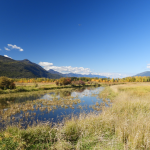
The Duck Lake area consists of a 1,500 hectare lake (Duck Lake), the Kootenay River, a series of nesting areas and a variety of ponds and channels.
Duck Lake is known for great large mouth bass fishing as well as amazing bird viewing opportunities. During spring and fall migrations, thousands of waterfowl use the lake as a landing pad, stopping to rest and feed on their long journey.
This area has the only dykes that you can drive a vehicle on – the dyke along the south end of Duck Lake. There are pullouts along the way where one can stop to view wildlife or park so one can walk along the dyke.
Please note that there are seasonal closures due to poor road conditions, so please check What’s Happening for up to date information.
For a map of this area, please download the CVWMA Access Map (PDF)
Also check out the Duck Lake Contour Map (PDF)
Summit Creek brings melted snow from the nearby mountains into the Kootenay River. There are some beautiful old growth cedar trees and access to many ponds and channels.
To access the area, there is a large pullout where one can park their vehicle directly off Highway 3 just west of the West Creston Rd turnoff (this is the road that goes to the Wildlife Interpretation Centre) .
One can walk over the Izzy Bridge at Summit Creek to gain access to the ponds and channels in the northern part of the area. It is approximately 10 km to get to the northern most part of Leach Lake. There are cottonwoods, open meadows and a series of ponds and channels that are used by a wide diversity of wildlife.
Some interesting sightings in the area include American White Pelicans from May to October, many species of grebes and waterfowl nesting in the summer, and lots of hawks and great blue herons. Elk and deer utilize the fields for foraging.
For a map of this area, please see the CVWMA Access Map (PDF)
The Six Mile Slough area consists of a series of ponds separated by dykes. Access to the ponds can be seasonally limited due to low water levels.
The area can only be accessed by boat along the Kootenay River.
For a map of this area, please see the CVWMA Access Map (PDF)
Dale Marsh is a small unit, located close to the US Border. It is a separate unit from the rest of the CVWMA. It consists of some small ponds and is 1,000 acres in size. It is surrounded on all sides by private land.
One can access the dykes but please be respectful of the surrounding private property.
Drones or unmanned air vehicles (UAV) :
Recreational drone use – Prohibited
The operation or use of a recreational drone (aka. Unmanned air vehicle – UAV) is prohibited within the Creston Valley Wildlife Management Area (CVWMA).
Report a drone
Please report any sightings of UAV use within CVWMA to our main office at 250-402-6900, an or email askus@crestonwidlife.ca with details and location


